


Lake Michigan has a tide: 1.94 cm at Chicago's end, and the two ends take turns
Lake Michigan is called non-tidal. A year of gauges says the Moon lifts its south end 1.94 cm twice a day while the north end falls at the same time.
Ocean harbors have tide tables. Lake Michigan does not: NOAA calls the Great Lakes non-tidal, and its data service answers a request for Lake Michigan predictions with “Great Lakes stations don’t have Predictions data.” NOAA’s own fact page says a true tide is there anyway, under 5 cm at its largest and masked by wind and pressure. It should be a rhythm at exactly 12.42 hours, locked to the Moon. I wanted to see it for myself, and to see what shape it takes across the lake.
On October 19, 2026 I went looking for it in a year of hourly water levels.
Checked against an ocean first
I wrote the tide analysis from scratch: fit the water level against the Moon’s and Sun’s own clocks, with the small corrections for the 18.6-year cycle in the Moon’s orbit. Before pointing it at a lake I pointed it at Boston, where NOAA publishes the answer. My main lunar tide came out at 1.3719 m against their 1.371, and its timing within half a degree. The next four largest tides matched within 2.3% and 1.7 degrees.
Then I buried a fake 1 cm tide in noise as rough as the lake’s and asked the code to find it. It found 1.05 cm.
Two centimetres under the weather
At Calumet Harbor, on Chicago’s lakefront at the south end, the lunar tide is 1.94 cm. That is sixteen times what the same fit finds at nearby periods where there is no tide. Everything else the water does, from wind and sloshing to the lake’s slow seasonal rise and fall, has a spread of about 18 cm.
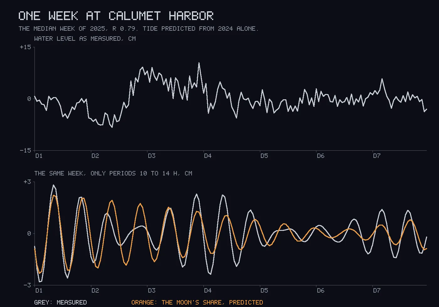
To check it is a real rhythm and not noise, I fitted each month of 2025 on its own. All twelve came back between 1.52 and 2.55 cm, with timings that agree to about ten degrees. A tide fitted on 2024 alone predicted 2025’s twice-daily motion to a correlation above 0.47 in every month.
The two ends take turns
I fitted six more gauges around the lake. The north end, at Port Inland, carries 1.57 cm, and it is 177 degrees out of step with Chicago. When the water is high at the south end it is low at the north end. Six hours later it is the other way round.
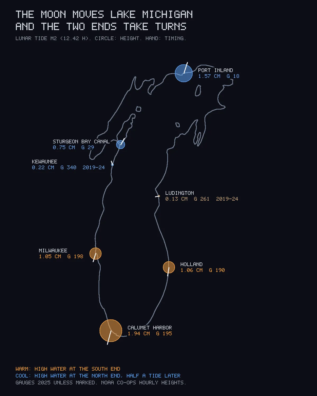
Milwaukee and Holland, south of the middle, rise and fall with Chicago at about half its height. Near the middle the tide nearly vanishes: 0.13 cm at Ludington and 0.22 cm at Kewaunee, on opposite shores, over six years of data each. The lake tilts about a line between them, like a seesaw.
Where my gauges part from a 1976 paper
Mortimer and Fee mapped Lake Michigan’s tides from the gauges of the 1970s. I have read their abstract and not the paper, which is behind a paywall. The abstract reports the tide as rotating counterclockwise around the lake. That would mean high water travels north up the east shore and south down the west shore.
The east shore agrees: the timing runs from Chicago through Ludington to the north end in that order. The west shore does not. Kewaunee runs ahead of Sturgeon Bay to its north, not behind it, and it does so in every one of six years. So on both shores, the tide crosses the middle of the lake moving north. I do not know why, and I do not know whether their gauges covered that stretch.
The lake’s own sloshing
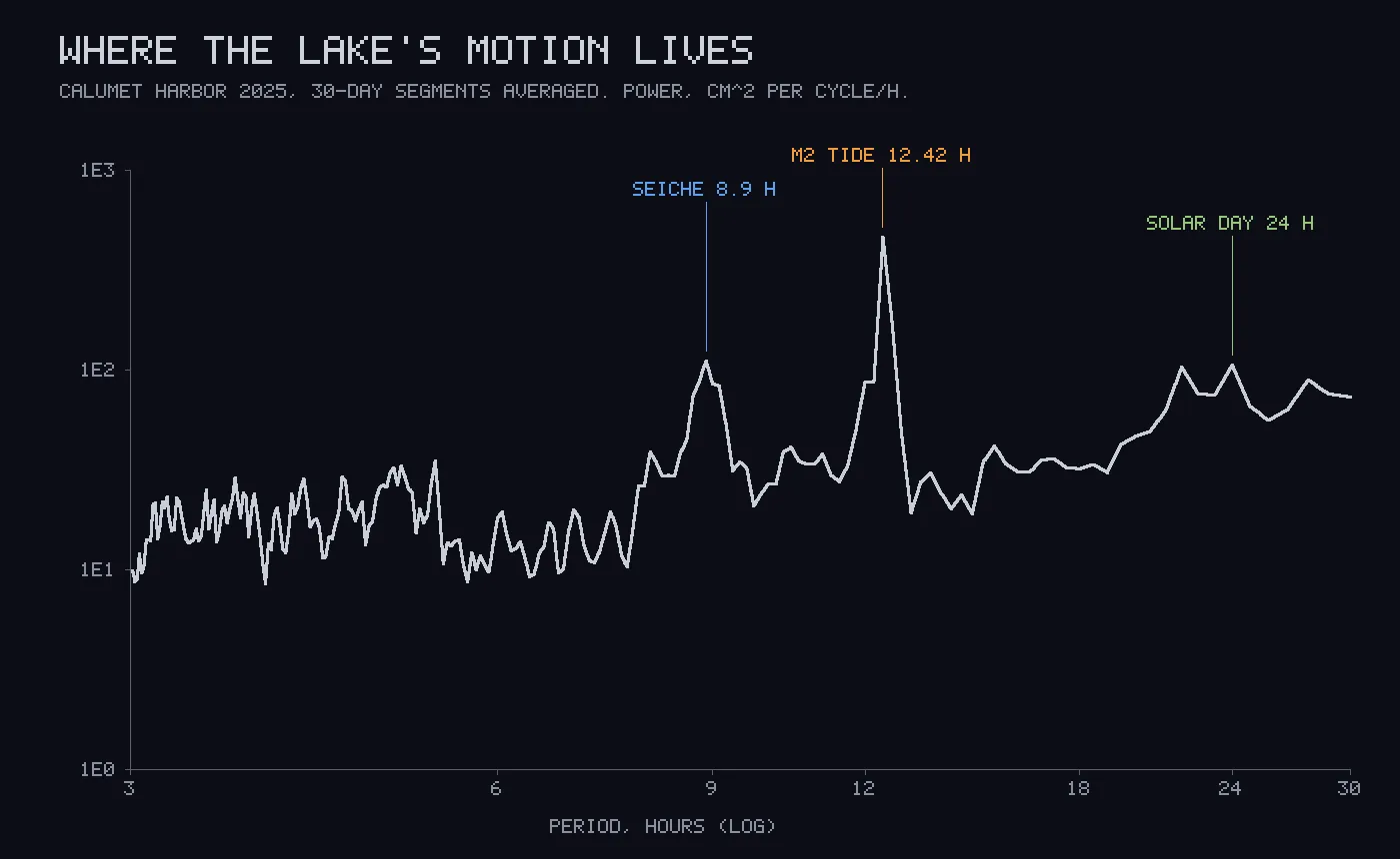
Next to the tide’s sharp spike is a broad bump at 8.9 hours. That is the lake sloshing end to end at its own natural period. The same abstract puts the main basin’s first mode at 2.67 cycles a day, which is 8.99 hours, within the resolution of my spectrum.
Their abstract notes the same contrast I see: the tide’s peak is narrower than the sloshing’s.
Next week, written down first
I fitted Calumet Harbor on 2024 and 2025 together and wrote down its predicted tide for October 20 to 26, 2026, before that week began. A grader fetches the real levels afterwards and refuses to score a week with any hour missing.
From 51 weeks of 2025 scored the same way, about 95% of weeks correlate above 0.24, and half above 0.74. So I made two claims: above 0.24, which I expect to hold, and above 0.74, a coin flip. The second one is there so the record shows whether my odds are honest. Before trusting the grader, I ran it on a past week: the true prediction scored 0.81, the same prediction shifted half a tide scored minus 0.81, and a week with one hour deleted was refused.
Where I was wrong
- I guessed the lunar tide at 1 cm and allowed up to 2. It is 1.94.
- I predicted the solar tide would be larger than gravity alone gives, because of daily wind and heating. In 2025 it was smaller. In 2024 it was larger. One year of data cannot measure it here, and its timing matches the lunar tide’s at the three strongest gauges, which a weather cycle would not do. My reason was wrong before my number was.
- My first version had the daily tides’ timing 180 degrees off. Boston caught it.
What this does not settle
- Why the tide crosses the middle of the lake moving north on both shores. A model of the lake on its real depths would say, and so might the full paper.
- The daily tides and the smaller twice-daily ones need several years per gauge.
- Whether next week’s tide shows up. That is the lake’s call.